The network of old unpaved roads is one of the striking aspects of mining districts in Nevada, nor more so than on the Comstock. The “ore roads” were the main way that mined ore, lumber, goods and people were moved on the Comstock. While the Virginia & Truckee railroad from 187? On provided localized service, even the railway was dependent on the mule wagons to distribute materials across the Comstock.
From the standpoint of archaeologists and geographers examining past cultural landscapes on the Comstock, the road network provides critical and unique evidence of past use. As in many mining districts other evidence of past use is very limited (as noted by Hardesty 2010, Obermayr & McQueen 2016 among others).
The habitation/use areas were relatively short term, largely temporary framed structures, on the Comstock almost all were of light wood post framing with canvas roofs, leaving little surface evidence. Dumps were scattered and with the exception of metal cans/tins, largely biodegradable. Ceramics were relatively rare (and apparently recycled) and glass fragile.
To understand the use patterns in mining areas you must understand the extractive mindset that underlay most perception and decision making related to land and place (Goldman 1981). The landscape and place were transient and viewed in purely economic terms (in contrast to settlement as per Jackson’s 1953 essay).
At most mining districts, extremely so on the Comstock, one way this was manifest was in the almost hyper re-use/recycling of all material, from structures to objects, so most residential and manufacturing/commercial sites were stripped of any usable material the minute they were abandoned. It was also frequent to move entire structures to other locations (from Silver City to Auburn or Johntown to Dayton for example).
The best example of how all-encompassing this was is the almost complete disappearance of the settlement of Johntown below Silver City, despite this being a major complex of mills and services (bars, stores, etc.) in the early period of the Comstock. Johntown today can be seen in the image above (note the lack of any structures).
Mining districts subject to consecutive redevelopment (such as the Comstock) reflect this behavior more than single period mining districts (such as the Cortez district) as waves of migrants would move into these areas. On the Comstock specifically, it was common (Canfield 2020) to not only reuse mining equipment, but to both blow up old equipment to recycle the metal and even to dig up mill foundations every 3-4 years to recover mill tailings left onsite.
A good example is almost total lack of any physical evidence of the McCone/Nevada Foundry in Silver City, which despite being a major presence and producer of large metal castings for much of the early period of Comstock mining, was not only completely demolished after a major fire in 1872 but remaining metal pieces/castings were blown into smaller pieces to be shipped up to Fulton Foundry in Gold Hill.
The roads remained, but the structures and most of the physical evidence has disappeared or was recycled.
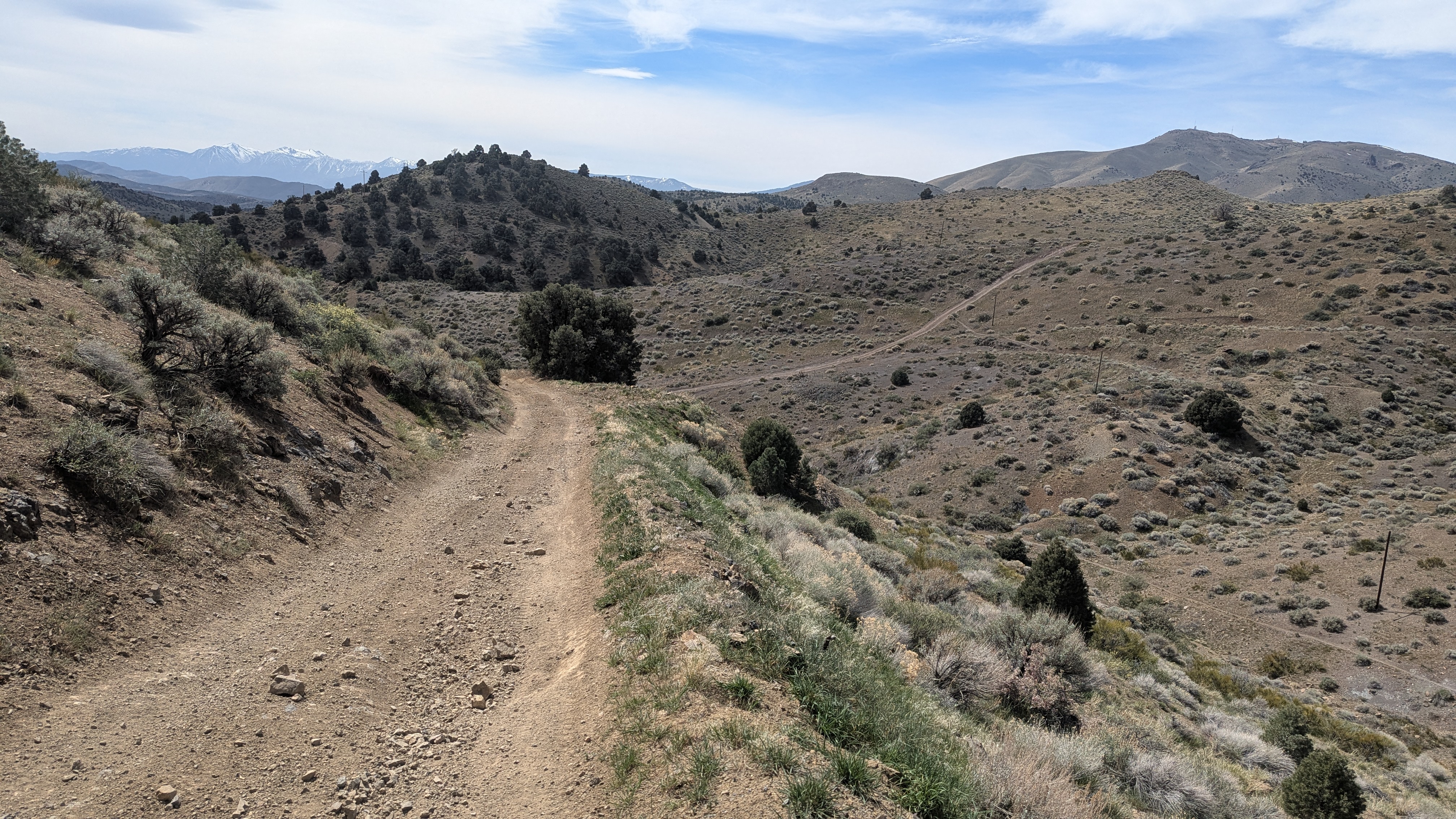
Middle Occidental Grade (ore road), central Comstock. Note all the various secondary and mine-specific roads on the surrounding slopes.
ROAD USE CATEGORIES:
I have arbitrarily divided the road network into four main categories:
A: Major improved mule-drawn ore roads, usually toll roads. These are defined by relatively gentle grades, evidence of heavy ore wagon use (high road center crests, deep wheel ruts). They tend to run down slope from the upper end of the Comstock in three directions: 1) to the Dayton mill cluster; 2) to the Carson River mill cluster; 3) to the Empire-Carson City mill and lumber center. Examples include the original Mound House-American Flat-Ophir Grade road, the Occidental Grade, the Dayton Toll Road and the Carson River Grade.
B: Second tier ore roads. These have little evidence of heavy use or improvement, but they follow the same criteria of gentle grades. These tend to link from mine clusters to category “A” major toll roads, or to link between toll roads as alternative routes. Most of these probably reflect changing mine-mill relationships. A good example is the short road down from the Occidental Grade to the Phoenix Mill complex in Johntown.
C: Single mine complex roads. These show evidence of little improvement and long-term use and frequently have more radical grade/elevation changes. A good example of this category is the “Foreman Mine grade” road, leading from the Foreman Mine complex to the Occidental Grade Toll Road. A large portion of the old road system visible on the Comstock in Google Earth reflects this specific category.
D: 20th century roads. A large proportion of the roads visible on the Comstock today reflect the switch to gas/diesel ore trucks in the 20th century. These roads are distinguished by several factors, most notably being the radically steeper grades and much flatter road surface (modern trucks don’t have the high center ground clearance of 19th century ore wagons). In some cases it appears that old ore wagon roads were replaced with parallel ‘truck’ roads, possibly due to clearance issues, an example being the abandonment of the lower section of the Old Occidental Grade with the modern Dayton Toll Road.
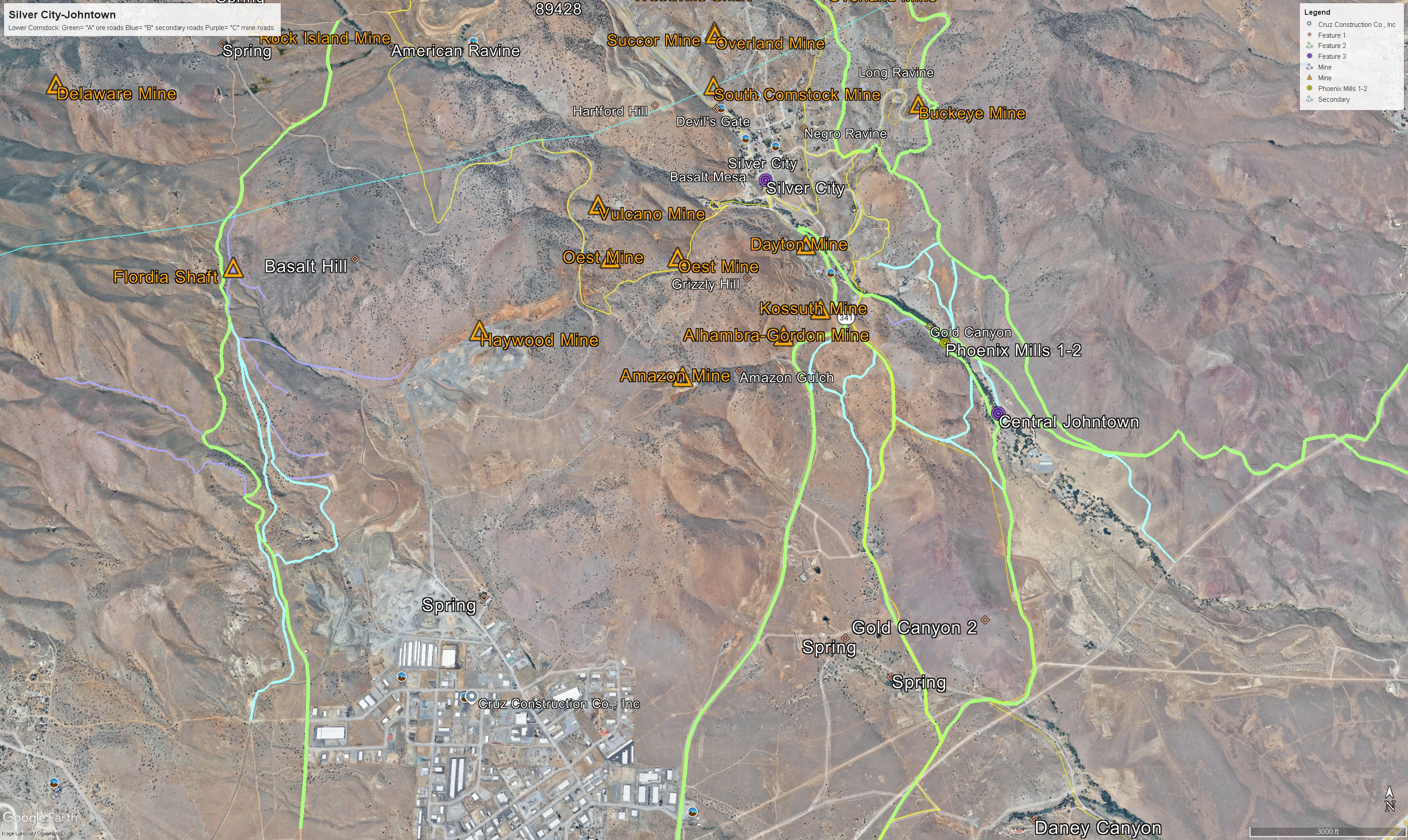
The lower Comstock: Silver City-Johntown, Mound House to the left [roads mapped to date]:
Green= “A” ore/toll roads; Light Blue= “B” secondary roads; Purple= “C” mill roads
Cited Sources (all of these are good reads):
Canfield, Kaylene 2020. News Clippings from Silver City Nevada: 1863-1874. Overtun: Anderson.
Goldman, Marion 1981. Gold Diggers and Silver Miners: Prostitution and Social Life on the Comstock Lode. Ann Arbor: Univ. Michigan Press.
Hardesty, Donald 2010. Mining Archaeology in the American West: The View from the Silver State. Lincoln: Univ. of Nebraska Press.
Jackson, J.B. 1953. “The Westward Moving House: Three American Houses and the People Who Lived in Them”, in Landscape Vol. 2/3 (11-42).
Obermayr, Erich and Robert McQueen 2016. Historical Archaeology in the Cortez Mining District: Under the Nevada Giant. Reno: Univ. of Nevada Press.
PROJECT MAPPING:
Mapping of the road network on the Comstock is an ongoing project. The current files to date can be downloaded as kmz files and imported into Google Earth. I recommend that you use Google Earth Pro, which is a free download (in a PC/Mac) or in the web-based version, as the files are large and some functions are disabled in the tablet/phone versions.
KMZ FILES: https://drive.google.com/drive/folders/1HnEUc9qaMWQsahy777-Rsl8LFkMfPEeS?usp=sharing
GUIDE ON HOW TO USE GOOGLE EARTH FILES:
Google Earth uses a unique file format called kmz files. These allow efficient compression of text and locational data for sharing with other users.
To Use the kmz Files
- download the kmz file(s) you want to view
- open a copy of Google Earth
- In Google Earth, go to the upper left hand corner, click on files, and go down to the ‘Open’ option.
- find the kmz file you downloaded and click for it to be opened.
- Google Earth will load the file information into your copy of Google Earth.
- If you have multiple platforms or copies of Google Earth, you will have to load the kmz file(s) into each copy.
- To make life easier, you should probably go back and place all the new kmz files under a new topic heading such as Old Hawaii files.
- When you go to close Google Earth, it will ask you if you want to save the ‘Temporary’ files [which is where it stored your downloaded files]. Click yes, otherwise when you open up Google Earth next time the new files will have disappeared and you will have to reload them.
- As we update the kmz files for various categories or locations, we would recommend that you delete the older version you have in Google Earth and replace it with the more recent version, otherwise you will end up with multiple sets of material.
