The OLD HAWAI’I GOOGLE EARTH PROJECT is run by the Behavioral Sciences Program and Service Learning Program at Chaminade University of Honolulu. The lead Investigators are Dr. Richard Bordner (Anthropology/Geography) and Candice Sakuda (I’olani School)
The goal of the project is to embed pre-European and historic place names, old photographs, old maps and traditional place-based stories from a number of publically-available sources into Google Earth for public education and to increase public awareness of Hawai’i’s past. Members, largely students, both research, validate and input data based on either categories or regions. Students who work on the project as a Service Learning assignment gain in their ability to work in the Google Earth platform and also learn how to analyze place identity, changing landscapes and various forms of local identity and local history. The end date for project postings is set at 1959 (statehood).
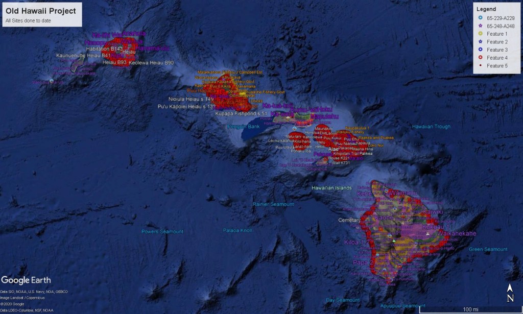
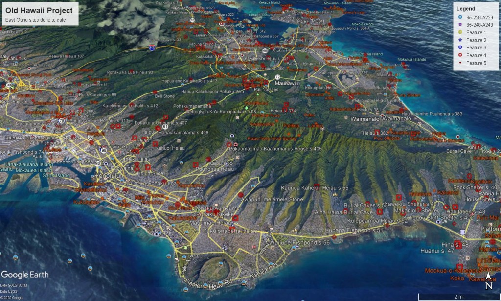
To date (late 2024) we have entered in the ahupua’a boundaries for all islands; all named places (from USGS 1950s maps) for all islands; all of Bennett’s Kaua’i sites (Archaeology of Kauai 1931); all of Sterling’s Maui sites (Sites of Maui 1998); all of McAllister’s Kaho’olawe sites (Sites of Kahoolawe 1933); all of Reinecke’s Hawai’i Island sites (Survey of Hawaiian Sites 1930/1999); all of Hudson’s East Hawai’i Island sites (Survey of Hawaiian Sites 1933 ms) and now all of Sterling & Summers’ O’ahu sites (Sites of Oahu 1978). As an offshoot of the Palolo-Pukele Project we have completed mapping of Land Court Award (1848-1853) testimony for all the ahupua’a of Waititi and the District of Lahaina, Maui. We are now working on adding downtown Honoruru and the Pearl Lochs region of O’ahu (now more commonly called Pearl Harbor). The ongoing (we are still actively working on this section) kmz files are available for download if you switch over to the page (tab) at the top of the Great Mahele page.
I have recently completed transferring the Wall 1893 map of greater Honolulu into Google Earth-while it is a later historical document from the end of the Monarchy, it is striking both in its detail and also providing a very rich image of Honolulu at this point in time. Of major interest is the patterns of land use and very large wetfield systems still dominating most of Waititi. Again available as a kmz file below.
Given the large number of sites and the large file sizes, the current kmz files for all the islands are stored in a folder which you can access to download the files and add to your copy of Google Earth. Instructions for adding these files to your copy of Google Earth can be found below. For each island there are a number of kmz files which are classified by the type or function of archaeological-historical features. All files should be downloaded and opened in Google Earth to get the complete sets to date.
GUIDE ON HOW TO USE GOOGLE EARTH FILES:
Google Earth uses a unique file format called kmz files. These allow efficient compression of text and locational data for sharing with other users.
To Use the kmz Files
- download the kmz file(s) you want to view
- open a copy of Google Earth
- In Google Earth, go to the upper left hand corner, click on files, and go down to the ‘Open’ option.
- find the kmz file you downloaded and click for it to be opened.
- Google Earth will load the file information into your copy of Google Earth.
- If you have multiple platforms or copies of Google Earth, you will have to load the kmz file(s) into each copy.
- To make life easier, you should probably go back and place all the new kmz files under a new topic heading such as Old Hawaii files.
- When you go to close Google Earth, it will ask you if you want to save the ‘Temporary’ files [which is where it stored your downloaded files]. Click yes, otherwise when you open up Google Earth next time the new files will have disappeared and you will have to reload them.
- As we update the kmz files for various categories or locations, we would recommend that you delete the older version you have in Google Earth and replace it with the more recent version, otherwise you will end up with multiple sets of material.
GOOGLE EARTH ISLAND-SPECIFIC ARCHAEOLOGICAL-HISTORICAL SITE FILES (kmz) for DOWNLOAD:
Hawai’i Island Archaeological-Historical Sites:
https://drive.google.com/file/d/1HEybpcksItFzGs9b52UuDMF7zDwDV0il/view?usp=sharing
Kaho’olawe Archaeological-Historical Sites:
https://drive.google.com/file/d/1i16BKtxX9myDl723CG7U071xPM-Zlipv/view?usp=sharing
Kaua’i Archaeological-Historical Sites: https://drive.google.com/file/d/1y00hqWRCU1T7LxEca08k4U76LRP6DTqj/view?usp=sharing
Lana’i Archaeological-Historical Sites:
https://drive.google.com/file/d/1a_brR1CkHTmTl-u7BJ4YfUfU8N_OYB-B/view?usp=sharing
Maui Archaeological-Historical Sites:
https://drive.google.com/file/d/1vkV7oaFUcegX06-L6f-6nKm9-EIpA1sm/view?usp=sharing
Moloka’i Archaeological-Historical Sites:
https://drive.google.com/file/d/1o_PfF8SwrN1QZp6JnrJCST4lF-YNXHic/view?usp=sharing
Ni’ihau Archaeological-Historical Sites:
https://drive.google.com/file/d/1lqeTLX_cxM6G_M1N-YFtFiN9Ml_Vw0Bj/view?usp=sharing
O’ahu Archaeological-Historical Sites:
https://drive.google.com/file/d/1YJsEiUbNCin2-8EzNnxRcQaO2RhmiIAD/view?usp=sharing
Greater Honolulu in 1893 from Wallhttps://drive.google.com/file/d/179AzIplXXm3jEI92Cr3rN5MtpgsJqaOw/view?usp=sharing
Wall map pdfhttps://drive.google.com/file/d/1IWtEuToMX9EscaMEfgBS0DbboVU5BhJ1/view?usp=sharing:
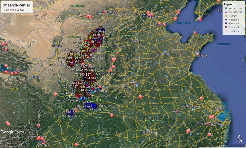
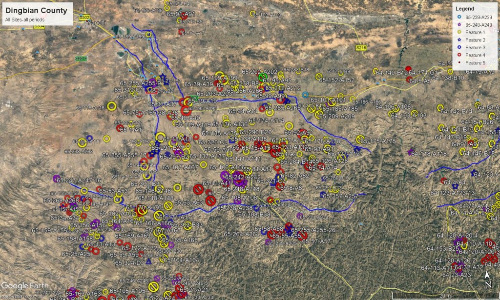
SHAANXI PROVINCIAL DIGITAL HISTORIC PRESERVATION PROJECT consists of moving the archaeological and historical sites recorded in the the Zhongguo Ditu Wenwu Shaanxi [the Archaeological Atlas of Shaanxi Province 1989], into Google Earth. This involves two major steps: 1) the reinterpretation of location from the paper maps in the Atlas into Google Earth (which has fairly large margins of location error); and 2) scanning the related site descriptions into place notations in Google Earth. Currently I am placing both Google Translate English text and Adobe OCR Chinese text for each site. This is a slow process.
To date a total of 23 counties have been placed into Google Earth. This equates to over 4100 archaeological sites and the relevant text entered into the Google Earth system. In the interests of maximizing the movement of the Atlas data into Google Earth, the majority of site descriptions have been translated automatically by Google Translate with limited additional editing for clarity. All work continues under supervision of the Shaanxi Provincial Historic Preservation agencies. The current files have been made available on this website as downloadable kmz files along with instructions for use. It should be noted that site locations are problematic given the relocation of sites (and inherent errors) from the printed maps into Google Earth, and machine translations are of course always problematic, though sometimes entertaining. To link the Atlas to other material, I have started a separate layer of Shaanxi sites from Zhou (1987) The Land Within the Passes, an excellent visual atlas, and sites that are marked in Google Earth (as of 2024).
As with the Old Hawaii Project the Shaanxi Atlas Project files are available below. Follow the same instructions as given above to add them to your copy of Google Earth.
HERE ARE THE CURRENT FILES OF THE CURRENT SHAANXI PROJECT BASED ON THE SHAANXI WENWU DITU ATLAS. NOTE THAT DUE TO FILE TRANSFER ISSUES WE WILL ONLY BE PUTTING IN ROUGH ENGLISH TRANSLATIONS OF THE SITE DESCRIPTIONS (via edited Google Translate 2022):
Shaanxi Settlement Category (all periods): https://drive.google.com/file/d/1GkvaNoFPooQufy9GwYo3YHrEGFWDADiE/view?usp=sharing
Burial Category (all periods): https://drive.google.com/file/d/1u2qFANuKy83eFC01-nYwV1Lc66X6IfEY/view?usp=sharing
Religious Category (all periods): https://drive.google.com/file/d/1NIMFIxe4S0ms5YII-WrJgUxdSJx4Yrde/view?usp=sharing
Stele-Petroglyphs Category (all periods): https://drive.google.com/file/d/1rEPZ3FyYK-4pLmyERB-mzPRvBuy4x4Rc/view?usp=sharing
Sites (largely historic): https://drive.google.com/file/d/1LDmMl3DZYsr19m6n0-BhkjuC4N_f5M_2/view?usp=sharing
Other Sites (largely out-of-situ finds): https://drive.google.com/file/d/1LUjY-yLixulPTUtRlIX9S-a47hYA3zt4/view?usp=sharing
Great Wall Sections (all periods): https://drive.google.com/file/d/1gtqH9v7MF-RPAy5e_jVq1COg0P5UuOIM/view?usp=sharing
Combined ‘Famous Sites’ (Zhou sites and Google Earth embedded ones): https://drive.google.com/file/d/1YV_ZDq47EyFa4f9N_xl0kG0gc445Atgq/view?usp=sharing
Sites embedded in Google Earth: https://drive.google.com/file/d/1Of9Apv_511T8TOUyORCLV6kE-ajMEv-B/view?usp=sharing
Sites from Zhou 1987 work: https://drive.google.com/file/d/1uYdwXTXmbPIeqQ53wb3djKukD0qcDhiH/view?usp=sharing
The process to add the kmz downloads to your copy of Google Earth is the same as with the Hawai’i Project.
SHAANXI CULTURAL RELICS ATLAS PROJECT STATUS
The Peoples Republic of China is home to one of the world’s greatest collection of archaeological and historical sites. Given the intellectual traditions in Chinese society, great value has always been placed on the past and how it informs the present. However with long periods of political instability and destruction, including the all of the 19th century and the entire first half of the 20th century, there was little interest or ability to locate and protect the archaeological and historical heritage of China. Soon after the founding of the Peoples Republic in 1949 the need to identify and record this heritage become a centerpiece of the Chinese state.
Starting in 1956 a country-wide archaeological and historical inventory was conducted which ran for several years. In 1981 a second, much more comprehensive national inventory of archaeological and historical was undertaken, largely under supervision of the various Historic Preservation Units at the Provincial, County and local level. This survey continued into the late 1980s.
As a result of this initiative an enormous amount of data was recovered, with one result being the Atlas of Chinese Cultural Relics which consists of 31 volumes and covering the entire country. All available information as of 1986 was entered into the various volumes to serve as both a compilation of data and also as a critical planning tool for the public and private sector.
The first volumes were printed in the late 1990’s. By that time the growth of digital data and GIS systems was becoming central to the process of recording and preserving the archaeological and historical heritage globally. Ironically, the enormous size of the Atlas makes conversion into digital format difficult as all data, both text and graphic, has to be converted by hand into a digital format. Given the rapidly changing forms of GIS systems, conversion runs the risk to moving onto a digital platform which becomes extinct, a very real problem with most digital archival materials.
After conversations and meetings with Northwest University Xi’an and the Shaanxi Archaeological Institute (the Provincial Historic Preservation Unit for Shaanxi Province), in 2010 the Behavioral Sciences Department of Chaminade University of Honolulu began work on the movement of the data from the Zhanguo Wenwu Ditu Ji: Shaanxi (map volume, text volume) into XMap 7, a DeLorme GIS system, under supervision by the SAI. This was chosen due to ease of use, the ability to control access to data and the relatively low cost. While work to convert the initial 10 counties proceeded, it became clear that commercial GIS systems, and XMap in particular had several major failings. They restrict access to owners of the platform, and are subject to fairly frequent upgrades in the application. In many cases a user is required to purchase the updated app to continue work in the GIS, which over a short time adds both to the overall cost and also to the learning curve as each new version of the GIS has different procedures and functionality.
With the move of Google Earth into a more robust version (Google Earth Pro) many of these concerns were resolved. The Google Earth platform is in use worldwide and updates are backwards compatible. While some functionality and control is lost, the increase in convenience and accessibility is dramatic, with the ability to access the database from a number of different platforms, especially tablets and smartphones. This enormously increases the practical functionality of the final product as it can be easily accessed by all levels of Historic Preservation Units and other agencies, especially in a field setting.
From 2013-2015 Google gave the Behavioral Sciences Department, CUH a series of yearly grants to support the conversion and movement into the Google Earth platform.
As the first stage of the project, all maps and text from the two volumes of Shaanxi Wenwu Ditu were scanned into digital files as pdfs. All text was been modified into a readable rtf file format through the IrisScan application, totaling over 1200 pages of text. All maps were converted into jpegs for ease of transfer into Google Earth.
As of January 2024 a total of 16 counties have been placed into Google Earth. This equates to over 5200 archaeological sites and the relevant text entered into the Google Earth system. The current goal is to have all identified sites from the print Atlas into Google Earth with site numbers by 2027 with rough (Google Translate) English site descriptions included. We have found that Mandarin (Putonghua) text is getting corrupted in file transfer for technical reasons we can’t resolve at this time, though we will post the scanned (pdf) images of the original Atlas pages for reference purposes.
